This long distance footpath, crossing the Netherlands from West to East has been described in three stretches: The Hague – Amersfoort, Amersfoort – Deventer and Deventer – Oldenzaal, where is connects to the German Toeddenweg, leading to Osnabrueck.
We’ve done the whole path, but this is the only tracks recorded, in the Western part: in Garmin, GPX and CSV format.
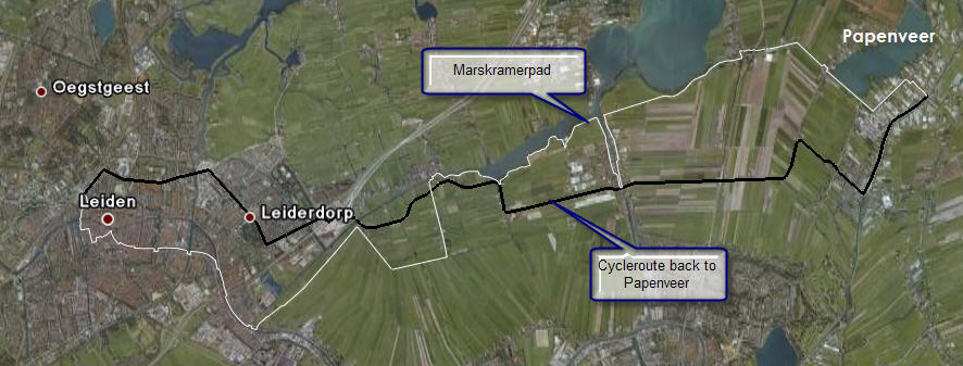
We parked our car near the station in Leiden, cycled to Papenveer (25 Km) and parked it there, next walked back to Leiden following the path description (28 km) and pickup our bikes on the way home.
Month: November 2007
Putten
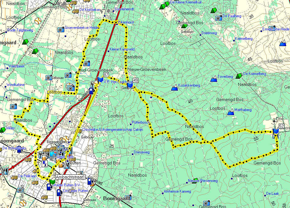
A year ago, we walked a 20 Km route near Putten, prepared by a number of volunteers of the wanderer’s club in the town. It ran through woods and farmland.
Just the track is available – no images – as Garmin database, in GPX and in CSV format.
Appel – Gerven
The tourist boards and farmer organizations in the area named “Gelderse Vallei” – the low lands between the Veluwe and Utrechtse Heuvelrug – have setup a number of walks and cycle routes. We combined two of the walks: one that traverses the Appel estate, and the location just North called Gerven, about 18 Km. We parked our car at the parlking lot of the church in the village of Huinen, on the road leading from Voorthuizen to Putten, and walked over country roads – paved an unpaved. Starting out cold and misty, but during the day it cleared and became quite sunny.
These are the images. The track can be downloaded in Garmin, GPX and as CSV formats. The waypoints can be downloaded separately as a .CSV file
Rheinsteig: Braunach – Kamp – SanktGoarshausen
On November 6th, we travelled to Germany, to spend a few days in a hotel in Kamp, a place opposite Boppard, to walk two stretches of the long distance path between Bonn and Wiesbaden: the Rheinsteig follows the Eastern banks of the Rhine, sometimes diving down to villages on the river bank, and climbing out of the valley steeply.
The two stretches we walked were said to be about 18km in length, but 21 would be a better estimate. Sometimes steep, but always goinmg up or down near starting ane ending point, on the top of the mountains following the countour – more or less – of the higher ground. Both would start with a short bustrip, from the town where we were dropped, walk back – uphill, over the flats lands on top, back to the hotel.
The first walk, after we arrived, was the part that traverses the hill over Kamp, a path we would bypass, done the same afternoon when we arrived.
Next morning, we were brought to Braunach, and walked up to the castle names Markburg, down to the river again, and uphill until we reached leven grounds. The path followed the gullies we passed, to stay on more or less the same height, slowly sloping down to the town of …, then passing over the hills to Kamp again. Most of this walk was througfh woodland of oak, beech and maple.
The second walk started in Sankt Goarshausen, steep up the mountain, down to Burg Maus, and the village below, croissing the river on the bottom of the valley and up again to the heigh grounds above, through woords of oak and beach, passing pastures and acres – going up and down, back to the village.
Originally, we would try to do a third part on the last day, from Kaub to Sankt Goarshausen, passing over the Loreley, but we decided not to do so, because even though we had proper clothing, it was quite cold and threathend to be wet and windy. So we spent our morning walking around in Boppard – a nice little town, in summer swearming with touorsist but far less busy now.
The images can be found here – day by day. The full tracks in Garmin format are available. The GPX formatted tracks are on a daily basis : 6, 7 and 8 november, as well as the CSV ones (day by day again: formatted tracks are on a daily basis : 6, 7 and 8 november