|
Austria 2012
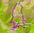
| The plan was to get to the summit of the nearest mountain thought to be reachable by foot: the Stubeck mountain, from one hut to the other. But it took us too much time to get to the first one, so we decided to pass the slopes and walk to the target hut directly. The summit had to wait. |
| Page | 1 | 2 | 3 | 4 | 5 | 6 | |
|
|
|
|
|
| ||||||
|
|
|
|
|
| ||||||
|
|
|
|
|
|
| 96 Images | Help |


