HOME  »  Holidays 2008 » 08-Jun  (15 Slides)     [Page 1 of 1] :: $text.jump-to  
  Up one level Help

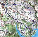
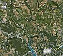
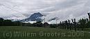
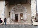
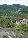
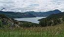
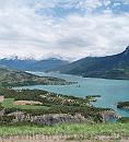
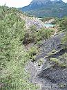
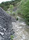
A short visit to Chorges, then to Lac de Selle-Porcon. crossing a peninsula. Finding our way was a bit troublesome, but it turned out just getting down a gulli.Next, following a path that had become very, very muddy, and get along an flooded trench - it had rained a lot in the past weeks and the water of the lake was much higher than normal.

3438ET * The intended route drawn on IGN map 3438ET. The blue line is what we actually walked, the cyan line what would be an alternative, or what we anticipated. But the track down from Les Curates was so muddy, and the route up Les Vergeter Oriental was told to be as bad, that we took an alternative route through the woods. * 2044 x 2000 * (1.18MB)
Google * The track - but the batteries gave at two-third so the remained is just the estimate. * 1032 x 925 * (260KB)
01-CutTrees * Cut trees along the road from Chorges to the route to Embrun * 2661 x 1185 * (210KB)
02-ChorgesMarket * Old housed in Chorges - the outer ring of the old city. Saturday is market day. * 3064 x 2224 * (602KB)
03-ChurchEntry * Church entry * 3072 x 2304 * (705KB)
  3438ET  
  Google  
  01-CutTrees  
  02-ChorgesMarket  
  03-ChurchEntry  
04-Fountain * A fountain on a square * 1470 x 2710 * (523KB)
05-Chapel * A small chapel near Chanteloube * 2304 x 2958 * (1.26MB)
06-Lake * Looking to the lake - the straight line at the other side marks the power lines from the power station at the barrage. * 2304 x 3072 * (1.23MB)
07-Joint * Looking down the lake towards the confluence of the Durance and Ubaye branches. * 3067 x 1800 * (568KB)
08-PicMorgon * Pic de Morgon on the other side * 3072 x 2304 * (582KB)
  04-Fountain  
  05-Chapel  
  06-Lake  
  07-Joint  
  08-PicMorgon  
09-Flowers * This plant is called Alpenrose in Gemany. * 2612 x 1854 * (1.15MB)
10-FlowerCloseUp * Flowers nmearby * 2392 x 2300 * (408KB)
11-BayStMichel * View over the Bay de Saint Michel - named after the chapel on the island that lies in front of it. * 2304 x 2535 * (531KB)
12-MudPathDown * Looking down the slope towards the bay. * 2304 x 3072 * (1.49MB)
13-HighWater * High water - the trees in the distance  stand dry normally, but the level was at least one meter above normal. We could just passs left along the stream * 2190 x 2990 * (1.15MB)
  09-Flowers  
  10-FlowerCloseUp  
  11-BayStMichel  
  12-MudPathDown  
  13-HighWater  
$text.updated-on 12-Sep-2008 23:22
(c) 2008 Willem Grooters, Rita ter Steege