HOME  »  Holidays 2008 » 10-Jun  (37 Slides)     [Page 1 of 2] :: $text.jump-to  
  You have reached the first page You have reached the first page      Up one level      Next page Last page Help

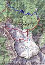
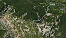
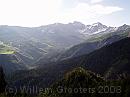
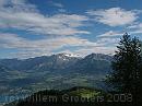
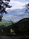
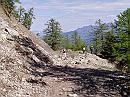
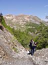
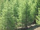
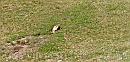
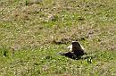
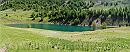
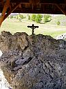
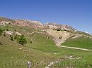
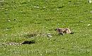
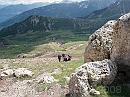
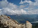
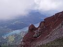
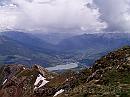
One of the best days - dry and sunny from the start - after weeks of clouded weather. Our host lead us on a walk to Pic de Morgon, but not straight to the summit, but along another path in the old gletcher bottom, one filled with ice, now snowfree and dry, except for a small lake that may be dry in late summer. The area hoses a lot of marmots. From the cirque, we climbed the South ridge and followed it to the summit, that offers a wide view around. From there, we took another path down, crossed the cirque once more to get beack to the car. During that walk, on the floor of the cirque, it started to rain, but we already had done the best part.

3438ET * The walk on the official map. The red route is the one we followed, and you can see we took just half of the cirque. 
There are two parking places: one that is easy accessable, and a second one requiring a drive up a bumpy forest road. The blue route ie an estimate of the five-kilometer walk you could do instead. * 1783 x 2536 * (1.38MB)
Google * The walk projected in Google Earth. The cyan walk is the track of our walk, and I found another parking place near Boscodon, and the dotted green line may be a walking route between the two parking places. But I guess this is not the one we were told of. * 1206 x 713 * (220KB)
01-ViewUnderway * Between the two parking places, you could get a glimpse of the landscape. This is into the Boscodon valley. * 1984 x 1488 * (217KB)
02-ViewUnderway * Looking over the Lac de Selles-Porcon, to some high peeks of the Alps. * 3072 x 2304 * (519KB)
03-SavinesLeLac * High above Salines-Le-Lac - and the bridge. This village replaces an older village that was destroyed when the lake was formed; its remains lay under water on the opposite side, just under the bridge, and can be seen when the level is lower - at the end of the summer * 1488 x 1984 * (384KB)
  3438ET  
  Google  
  01-ViewUnderway  
  02-ViewUnderway  
  03-SavinesLeLac  
04-Landslide * A landslide blocked the forest road - but we could easly cross. * 1984 x 1488 * (588KB)
05-CrossingTheSlide * Another landslide, a bit further on the route. * 1488 x 1984 * (573KB)
06-Woods * Larix forest - the needles just poping out * 3072 x 2304 * (1.26MB)
07-SouthRidge * A full view of Southwest ridge. Se would go up from the low end straight in front, coming in from left. * 4900 x 1705 * (858KB)
08-CirqueDeMorgon * Another view - somewhat wider, of the cirque. The road in front is the ususal way, we would follow the narrow track on the left, behind the trees. * 5250 x 1350 * (1.13MB)
  04-Landslide  
  05-CrossingTheSlide  
  06-Woods  
  07-SouthRidge  
  08-CirqueDeMorgon  
09-Marmot * Marmot not noting us walking by... * 1314 x 634 * (178KB)
10-Marmot * ..Shreek - someone's walking! Take care.... * 648 x 424 * (68KB)
11-Lake * This lake is all what's left from the icy conditions in winter. There is no exit - except vaporation. Or the water may leak away through cracks in the bottom. * 3524 x 1412 * (993KB)
12-Chapel * There is a small chapel near the lake. * 1488 x 1984 * (533KB)
13-EnRoute * Our route uphill leads left; ahead is the normal way we didn't want to take. It's a colourfull mountain, several colours appear at the surface. * 1984 x 1488 * (412KB)
  09-Marmot  
  10-Marmot  
  11-Lake  
  12-Chapel  
  13-EnRoute  
14-Hurry * Marmot heading for cover. * 1434 x 894 * (244KB)
15-LastClimb * Climbing to the ridge - the last meters - upward. * 3072 x 2304 * (1.31MB)
16-Preview * From the ridge you have a wide view on the lake already. * 3072 x 2304 * (632KB)
17-RedRocks * The Durance branch of the lake - green against the dark red of the montain - at this point. * 1984 x 1488 * (266KB)
18-Embrun * Peaking on the ridge, a view onto the other side: Embrun, where the Durance river enters the lake. * 1984 x 1488 * (318KB)
  14-Hurry  
  15-LastClimb  
  16-Preview  
  17-RedRocks  
  18-Embrun  
$text.updated-on 12-Sep-2008 23:23
(c) 2008 Willem Grooters, Rita ter Steege