HOME  »  Holidays 2008 » 15-Jun  (73 Slides)     [Page 1 of 4] :: $text.jump-to  
  You have reached the first page You have reached the first page      Up one level      Next page Last page Help

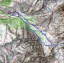
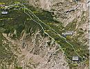
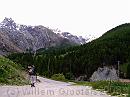
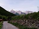
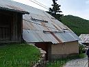
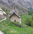
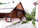
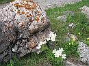
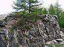
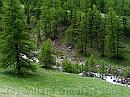
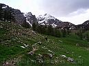
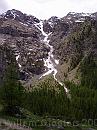
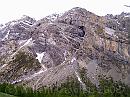
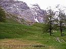
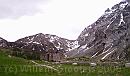
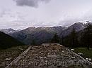
This route covers part of the GR56 we intended to walk, Fouillouse would have been place to stay overnight. The weather was cloudy and not very warm, but it started out dry, But the higher we got the Col de Vallonnet, the more rainy it got, and on the walk back it was slightly raining at times. A lot of rains means a lot of water flowing down the mountains, making is hard to cross streams at times, and stones rolling with the stream ruin the borders, washing away bridges, as we encountered. This is chamois country and we encountered two - one fled fast over a ridge, the other went the same way we walked for a time but then crossed an area with loose chips and went off site. Fouillouse is a no-car area, it's a very narrow, winding road to get there, and you have to park outside the village. A lot of people seem to walk, when we set off, the parking lot was quite full, but by the time we got back, it was almost empty.

3538ET * Use the IGN map 3538ET. We started out from the car park, went through the village and followed the GR5/GR56 to the Col de Valonnet, found our way along snowfields to the track just down 'Les Roches de Saint Ours' that peaked up between 2500 and 3000 meters, to find the bridge above Fouillouse practically gone, so we had to walk down the meadows to joint the GR5/GR56 to cross the bridge down the church. * 2536 x 2507 * (2.06MB)
google * The route's track projected on GoogleEarth. I forgot to enable tracking but what's shown is a pretty correct estimate. From the fortress, where we took a short rest (15-18), it's accurate. * 1017 x 785 * (210KB)
01-FullParking * A full car park (the area is well visited by walkers) in the midst of the mountains. * 3072 x 2304 * (439KB)
02-OffTheParking * The road off the car park towards, and a view what's to come; the range in the background mark the French-Italian border, about 5 kilometres East. * 1984 x 1488 * (365KB)
03-VillageRoad * The scenery when walking towards the village: Brec de Chambeyron in the distance, being the French-Italian border. But we could keep more to the right. * 1984 x 1488 * (402KB)
  3538ET  
  google  
  01-FullParking  
  02-OffTheParking  
  03-VillageRoad  
04-Shed * An iron-covered shed in the village, with beams to prevent snow sliding off. * 3072 x 2304 * (652KB)
05-VillageChapel * The village chapel. The GR56 would get up along here, from the bridge just visible on the right, under the trees. * 2304 x 2325 * (770KB)
06-WoodenShed * This would have been our 'hotel' when we would have done the GR56, coming from Larche. * 1984 x 1488 * (510KB)
07-Anemone * Some flowers - assumed anemone but it might well be something else. * 1488 x 1984 * (617KB)
08-AnemoneNearStone * Similar flowers bloom on more places, even near big rocks * 3072 x 2304 * (1.29MB)
  04-Shed  
  05-VillageChapel  
  06-WoodenShed  
  07-Anemone  
  08-AnemoneNearStone  
09-PlantsOnRock * Weathered rocks, covered with shrubs. * 3072 x 2304 * (1.53MB)
10-ValleyWoods * Looking down the river - we would get along the path between the trees on our way back. * 1984 x 1488 * (624KB)
11-OnTrack * Following the path up the valley. The top must be the Rocca Blanca, on the Italian border (3193m) * 3072 x 2304 * (910KB)
12-BrecDeChambeyron * Looking up to the range between Brec de Chambeyron and Rocca Blanca - this consist of a number of 'tete' s * 1984 x 1488 * (595KB)
13-DownRochesDeStOurs * A valley on the other side, in the Roches de St Ours: Ravin des Baumes * 1488 x 1984 * (443KB)
  09-PlantsOnRock  
  10-ValleyWoods  
  11-OnTrack  
  12-BrecDeChambeyron  
  13-DownRochesDeStOurs  
14-Ravin * A deep gorge in the mountain range - must be tens of meters deep and just a few wide on top. * 1984 x 1488 * (594KB)
15-MarkStone * This stone marks the area of the old fortress * 1488 x 1984 * (500KB)
16-FortDePlateLombarde * There are still a number of concrete bunkers hidden in the ground. * 1984 x 1488 * (549KB)
17-TakeARest * But all what's above level is more or less torn down: a good place to sit down and have a rest. * 1980 x 1166 * (301KB)
18-VallonDeSerenne * Looking over a roof onto the Vallon de Serenne, on the other side of Fouillouse. * 1984 x 1488 * (273KB)
  14-Ravin  
  15-MarkStone  
  16-FortDePlateLombarde  
  17-TakeARest  
  18-VallonDeSerenne  
$text.updated-on 12-Sep-2008 23:29
(c) 2008 Willem Grooters, Rita ter Steege