HOME  »  Holidays 2008 » 16-Jun  (45 Slides)     [Page 1 of 3] :: $text.jump-to  
  You have reached the first page You have reached the first page      Up one level      Next page Last page Help

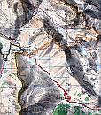
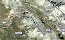
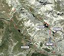
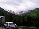
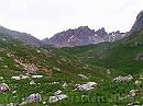
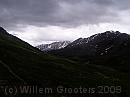
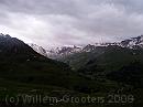
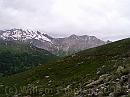
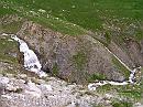
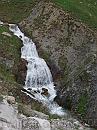
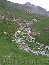
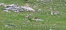
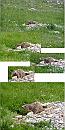
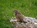
Today we walked to the Col de Roburent, just across Italian border. We could go along three nice lakes and return by road. Again, when starting off the weather wasn't that bad but by the day, it got wetter, and, more important, windier and colder. By the time we got to the summit, it was just over freezing point (centigrade), we met some wanderers wearing hats and gloves. They told us the route on the Italian side was rather fine until the lower lakes bet beyond that, it might get very difficult to pass. It was better to return the same way. Well, almost. A track we couldn't find going up, was easy to follow going down.

3538ET * The full walk - leading into Italy to the village of Argentura, and walking back along the road. But that would have been too long for today - we should have started much earlier. But the route from the small lakes leads to a north-faced valley and changes were it was impossible to cross. * 2536 x 2870 * (1.8MB)
Google * The tracking of this walk projected on a winterly GoogleEarth. * 1108 x 699 * (195KB)
Google1 * The full walk on GoogleEarth, it shows the possible problems above Argentura. * 961 x 848 * (185KB)
01-Mercantour * From the parking lot, looking straight into the Mercantour National Park * 1984 x 1488 * (233KB)
02-Signpost * Was this to be taken as an omen? * 1164 x 1296 * (211KB)
  3538ET  
  Google  
  Google1  
  01-Mercantour  
  02-Signpost  
03-Tulip1 * Tulips - aside * 2388 x 2132 * (280KB)
04-Tulip2 * Tulip straight from above * 1756 x 1496 * (148KB)
05-AiguilleJeanCoste * The range north of the Vallon de l'Orrenaye: Aiguille Jean Coste (2832m) * 1984 x 1488 * (381KB)
06-CreteDesBlavesjpg * Looking East, across the Italian border, to the Crete des Braves and the Col de Roburent - that is, the direction. * 1984 x 1488 * (172KB)
07-Gr5Gr56 * Looking into the National Park, over the route we would have taken: the GR56 runs down this valley as well, but turns off to Larche before getting to this area. * 1984 x 1488 * (180KB)
  03-Tulip1  
  04-Tulip2  
  05-AiguilleJeanCoste  
  06-CreteDesBlavesjpg  
  07-Gr5Gr56  
08-CreteDeChamois * The GR56 runs this direction, in the valley  beyond this slope. This range is just before Larche * 1984 x 1488 * (265KB)
09-OrrenayTorrent * A lot of water runs down the valley and cuts out new turns, and picking up even more streams * 1984 x 1488 * (587KB)
10-Closeup * A close-up of the waterfall - full height must be over 20 m * 2304 x 3072 * (748KB)
11-HeadingUp * The valley it runs through, the path is close to the torrent. * 1488 x 1984 * (469KB)
12-Marmot * This as, once again, Marmot territory; mostly you couldn't get very close. * 1555 x 685 * (165KB)
  08-CreteDeChamois  
  09-OrrenayTorrent  
  10-Closeup  
  11-HeadingUp  
  12-Marmot  
13-Wells * Water streams out of the soil. * 1984 x 1488 * (593KB)
14-Together * Two at a time - this is not very common. * 1208 x 566 * (134KB)
15-Refuge * A former hideout for shepherds and hunters, deserted and in ruins. But I guess it's still in use sometimes. * 1984 x 1488 * (555KB)
16-YouReNotThere * This time I could get quite close - about 3 meters. He kept an eye on me while doing his (or her) business, kept close to the boroughs * 2000 x 4000 * (1.24MB)
17-HeadUp * Aren't you gone yet? * 1984 x 1488 * (478KB)
  13-Wells  
  14-Together  
  15-Refuge  
  16-YouReNotThere  
  17-HeadUp  
$text.updated-on 12-Sep-2008 23:31
(c) 2008 Willem Grooters, Rita ter Steege