HOME  »  Rheinsteig - Goarshausen - Wiesbaden » 01-09  (40 Slides)     [Page 2 of 3] :: $text.jump-to  
  First page Previous page      Up one level      Next page Last page Help

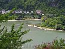
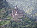
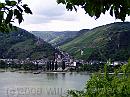
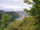
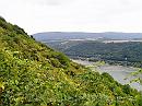
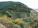
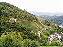
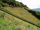
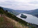
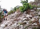
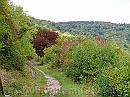
Second, started in Kaub, steeply uphill, and again, once out of the valley, the walk was fairly even, with an occasional ascend and descend - especially the long one down the Niedertal, and steep down to the river to follow. After Lorch - the stop according the guide, we continued through the vineyards to the camping site, halfway Assmannshausen.

14-LeadingTheStream * A medieval gutter: taming the stream. Just over a meter wide, it forms a canal where water could run down - more or less controlled. * 1984 x 1488 * (675KB)
15-OldWall * The road is walled as well. In early days, there could have been vineyards on top of it; nowadays it’s a nature reserve. * 1984 x 1488 * (594KB)
16-BacharacherWerth * The upstream edge of an island in the midst of the river - turbulent waters rather off-shore show low tide: heavy rocks under the surface. * 1984 x 1488 * (465KB)
17-BurgStahleck * Burg Stahleck above Bacharach, on the edge of the Rhine and Münzbach valleys * 1984 x 1488 * (430KB)
18-Bacharach * Bacharach - I think the artist is named after the village - spreads along the Rhine, and into the valley. The Northern slopes are covered with vineyards - since they face due South; the Southern slopes are mainly covered with woodland. * 1984 x 1488 * (360KB)
  14-LeadingTheStream  
  15-OldWall  
  16-BacharacherWerth  
  17-BurgStahleck  
  18-Bacharach  
19-Kaub * Looking back to Kaub, beyond the bend. * 1984 x 1488 * (477KB)
20-QuarrySpills * An old mine or quarry. Just by the look of the area. * 1984 x 1488 * (736KB)
21-ShadesOfGreen * Northern slopes are often covered with woods - showing many shades of green. * 1984 x 1488 * (439KB)
22-Vineyards * Vineyards facing West - in the Obertal; being protected by a small chapel: * 1984 x 1488 * (628KB)
23-ClemensKapelle * The Clemens chapel. We would go deeper into the valley to cross is, and come back along the other side - and pass the chapel on the road shown right of it. * 1772 x 1268 * (454KB)
  19-Kaub  
  20-QuarrySpills  
  21-ShadesOfGreen  
  22-Vineyards  
  23-ClemensKapelle  
24-Vineyards * In the back of the valley. You can clearly see the levels of grounds and the steepness of the slopes. It seems this vineyard offers a good living, despite the tilt of the grounds. * 1984 x 1488 * (553KB)
25-Vineyard * Most vineyards are gone, except for a narrow strip of grapes - just two or three rows wide, Probably for private use, by no means someone could make a living by this stretch alone. * 1984 x 1488 * (586KB)
26-LorcherWerh * There island before Lorch - like a big ship in the river. * 1984 x 1488 * (330KB)
27-DescentToLorch * A very steep descent, at times, over bare rock; slippery, and uneven, a troublesome way. * 1984 x 1488 * (619KB)
28-Woodland * But once the hard part was done, the path meanders through shrub that covers once-existing vineyards. * 1984 x 1488 * (591KB)
  24-Vineyards  
  25-Vineyard  
  26-LorcherWerh  
  27-DescentToLorch  
  28-Woodland  
$text.updated-on 23-Oct-2008 23:04
(c) 2008 Willem Grooters