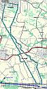
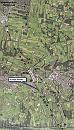
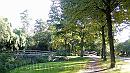
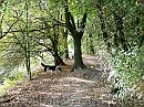
HOME  »  Leusden-Veenendaal 03-Oct-2007  (40 Slides)     [Page 1 of 2] :: Jump To  
  You have reached the first page You have reached the first page      Up one level      Next page Last page Help
00-Map * 25 kilometers, start and finish at the Hamershof shopping center. The track doesn't kame it all to Veenendaal, that is another  two miles or so the the southeast. * 509 x 950 * (177KB)
00-Google * The trach projected in GoogleEarth. The numbers refer to the picture locations. * 528 x 922 * (109KB)
01-Cohensteeg * The end of the first part of the Cohen Steeg in leusden. Do NOT cross the bridges, it won't bring you to the dyke... * 1984 x 1119 * (531KB)
02-PadOverDijk * The start of the path following the Valleikanaal. (Dug in the 1930's, following the bed of streams already there, and all material was deposited on this side, so that became the dyke) * 1984 x 1488 * (792KB)
03-Laagte * A low spot, so that means a pond. In spring, this area is home of many green frogs - and they make a lot of noise! * 1984 x 1488 * (493KB)
  00-Map  
  00-Google  
  01-Cohensteeg  
  02-PadOverDijk  
  03-Laagte  
04-GevallenBoom * A willow tree broke into pieces after a summer storm a few years ago, but it's still alive , at least, most of the branches, including the one that arches thhe path. * 1818 x 1347 * (628KB)
05-Richting * The wilder part of the path starts here. The path follows just right of these trees. * 1488 x 1984 * (774KB)
06-VoorbijDeBunker * Further on, it gets better (This is the part I like most) * 1488 x 1984 * (718KB)
07-Zandbank * Sand banks in the canal. The stream will meander within the limits of the canal,in a bend like this, it will follow the outer curve and leave sands on the inner one. * 1978 x 1167 * (444KB)
08-Doorkijkje * Looking trough a hole in the rather dense trees - becasue one has fallen and left an opening * 1984 x 1488 * (381KB)
  04-GevallenBoom  
  05-Richting  
  06-VoorbijDeBunker  
  07-Zandbank  
  08-Doorkijkje  
09-Schapen * Looking down the bend, sheep are grazing on the dyke's slopes. * 1488 x 1984 * (692KB)
10-Bocht * Since the dyke follows the canal, the path take a turn as well. * 1984 x 1488 * (644KB)
11-Laan * Autumn colors * 1984 x 1488 * (381KB)
12-Paalkop * Fungi in a pole * 1548 x 1452 * (351KB)
13-Meertje * A lake bewteen the dykes. The left one is an older one - part of a defensive structure, the right one the one of the canal diggers. This small lake is all thatt remained of the old stream. * 1984 x 1488 * (805KB)
  09-Schapen  
  10-Bocht  
  11-Laan  
  12-Paalkop  
  13-Meertje  
14-Loopgraaf * In the beginning of the second WorldWar, this area was destined to be the place where the Germans were to break the Grebbelinie - a line of defence, marking the west side of inundated lands. As a reminder, the trenches have been restored over about 100 meters. * 1356 x 1664 * (462KB)
15-Doorkijkje * Looking out the woods that cover the path, to the wooded area we are about to enter. * 1984 x 1488 * (505KB)
16-OpenPad * The path opens. * 1488 x 1984 * (516KB)
17-Doorkijkje * Looking onto wet lands. * 1488 x 1984 * (454KB)
18-Paddestoelen * Fungi aside the path - a whole bunch on what appears to be a treestump * 1984 x 1488 * (759KB)
  14-Loopgraaf  
  15-Doorkijkje  
  16-OpenPad  
  17-Doorkijkje  
  18-Paddestoelen  
Album last updated on 14-Oct-2007 21:59
(c) 2007 Willem Grooters, Rita ter Steege