HOME  »  Rheinsteig - Goarshausen - Wiesbaden » 03-09  (22 Slides)     [Page 1 of 2] :: $text.jump-to  
  You have reached the first page You have reached the first page      Up one level      Next page Last page Help

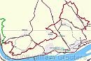
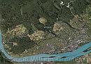
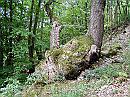
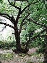
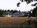
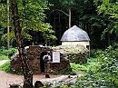
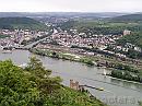
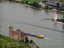
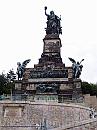
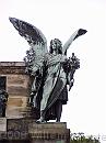
Day four: Assmannshausen to Johannisberg. This leg bends with the Rhine, eastward, where the Rhine streams wide in the Middle-Rhine plains; the route however keeps height, which means it runs far from the river. Nevertheless, it offers even wider views over a flat area, miles and miles away; Frankfurt is visible on the horizon. We passed the Niederwald memorial - erected to commemorate the founding of the German state in 1870 - and the victory over France that year. Since these sloes are facing south, wine growing is the main agricultural activity in this area. The higher grounds however are covered with woods. The weather forecast said it could rain. Well, it did for the last hour of the walk - it started when we left from the Antonius chapel, and it kept raining all the way back to the camping site.

Track * Assmannshausen marks the entrance of the Rhine, struggling through the Eiffel-Hunsrück-Westerwald-Taunus plateau. From here, the route runs to the east, on the slopes known as the Rheingau Mountains - the southern slopes of the Taunus plateau. Today’s walk starts at Assmannsshausen, and ends in Johannisberg - where we parked our bikes. It means a descent to lower grounds to get to Assmannshausen by bike - easier than climbing in the end. Finding them was a bit troublesome - we headed the wrong direction (South) but once directed to the right place (The Wine Palace) it was a piece of cake. * 1290 x 873 * (131KB)
Google-0903 * The projection on Google Earth shows that this walk followed the boundary of woodland and viniculture for most of the time. At times running trough woodland, at times between vineyards. It's also clear that the landscape has changed dramatically: Wide open, rather flat areas in stead of the narrow, steep and rocky passage North of Assmannshausen. * 1155 x 823 * (354KB)
01-Klinging * A tree bulging out of the rock, in our ascend over Assmannshausen. * 1984 x 1488 * (740KB)
02-Tree * The very same tree but shown form a different angle. * 1488 x 1984 * (628KB)
03-CastleNiederwald * Niederwald - a ‘castle’ used by the noblemen when hunting. * 1984 x 1488 * (496KB)
  Track  
  Google-0903  
  01-Klinging  
  02-Tree  
  03-CastleNiederwald  
04-Zauberhoehle * Close by there is the Magical Grotto - a manmade feature you could pass - in pitch-black darkness, ending in the domed building in the background. Well why not: * 1984 x 1488 * (570KB)
05-FlashedCorridor * Spying around with the camera, to find out how the turns would be. Not entirely honest, of course ;) * 1488 x 1984 * (482KB)
06-Corner * The alley curves several times and ands in an open space in the centre. * 1488 x 1984 * (367KB)
07-OpenSpace * Even flash didn't reveal all very clearly, just a faint idea where to go. * 1488 x 1984 * (361KB)
09-CentralRoom * This is the other end of the square room. Not the way to go. * 1488 x 1984 * (461KB)
  04-Zauberhoehle  
  05-FlashedCorridor  
  06-Corner  
  07-OpenSpace  
  09-CentralRoom  
10-Rossel * Once back on track we came upon the Rössel tower - a viewpoint over the valley * 1488 x 1984 * (549KB)
11-Bingen * looking out over Bingen, with the famous Mauseturm on the island in the middle, and Burg Eherenfels on this side, still high above the Rhine. * 1984 x 1488 * (486KB)
12-BurgEhrenfels-Maeuseturm * The ruins of Burg Ehrenfels, and the Mauseturm opposite, in the middle of the Rhine. * 1984 x 1488 * (270KB)
13-Niederwald * The Niederwald memorial commemorates the German unification in 1870, and the victory over the French in the same year. Erected as a gift to the First, all-German emperor Wilhelm I. * 1488 x 1984 * (299KB)
14-Servant * Prosperity on the right side, * 1488 x 1984 * (217KB)
  10-Rossel  
  11-Bingen  
  12-BurgEhrenfels-Maeuseturm  
  13-Niederwald  
  14-Servant  
$text.updated-on 23-Oct-2008 23:04
(c) 2008 Willem Grooters