HOME  »  Rheinsteig - Goarshausen - Wiesbaden » 31-08  (18 Slides)     [Page 1 of 2] :: $text.jump-to  
  You have reached the first page You have reached the first page      Up one level      Next page Last page Help

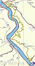
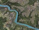
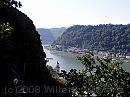
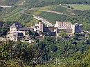
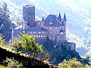
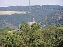
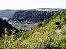
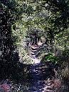
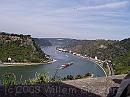
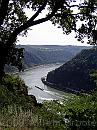
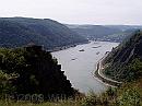
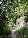
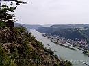
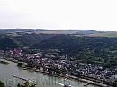
The first walk was the longest and heaviest of all - and the hottest. Sankt-Goarshausen, over the Loreley, Spitznack, Roßstein, and Dorcheid to Kaub. Twice a steep ascend - first to Burg Katz, down to the railroad and steeply going up again to get to the Loreley. Rewarded with stunning open view in both directions. One on top, the walk was fairly even, and Spitznack and Roszstein offer fine views as well. The walk over the plain to Dorcheid ended in a very steep descends to Kaub.

Track * Sankt Goarshausen - over the Loreley,  just below, or on the high grounds of the Taunus area - to Kaub. The longest walk, and the heaviest one. Nice weather, and rather warm. We parked our bikes at Kaub, drove on to Sankt Goarshausen, walked to the bikes and rode back along the river. Just half the distance. * 668 x 1244 * (124KB)
Google-0831 * The route projected on Google Earth, slightly rotated. The major direction was North to South. Images 1 and 2 were taken yesterday, when we took the Kaub ferry to cross the river. The rest of the pictures were taken today. * 1105 x 867 * (372KB)
03-SanktGoar * A tough climb from Sankt Goarshausen to begin with. It allows a view on the Rhine, and the city of Sankt Goar on the opposite bank, and the centre of Sankt Goarshausen on this side - settlements tend to spread along long distances because there is no room for expansion except along the river. * 1984 x 1488 * (305KB)
04-BurgRheinfels * Burg Rheinfels above Sankt Goar. One of the largest castles along the Rhine. * 1984 x 1488 * (591KB)
05-BurgKatz-Topview * its counterpart - not nearly as expanded: Burg Katz over Sankt Goarshausen; now, or previously, a hotel in the midst of partially abandoned vineyards. * 1984 x 1488 * (557KB)
  Track  
  Google-0831  
  03-SanktGoar  
  04-BurgRheinfels  
  05-BurgKatz-Topview  
06-BurgMaus * Looking back, Burg Maus that we passed on our earlier trip. * 1984 x 1488 * (556KB)
07-Forstbach-Outlook * From the Forstbach enclosure, far inland, Sankt Goarshausen stretches along the Eastern banks of the Rhine. It's clear that this part of the Rhine can be considered a canyon: Taunus plains on the right: rather flat, and high above the river; the same applies to the landscape on the other side: Hunsrück, not visible here. * 1984 x 1488 * (615KB)
08-Path * The path follows old rural roads between mostly abandoned vineyards - above the wall on the left, but same level on our right * 1488 x 1984 * (724KB)
09-OldfarmHouse * The loop returns to the Southern stretch of Sank Goarshausen, opposite this old barn. Our next leg was beyond this barn - uphill once more: Up the Loreley. * 1984 x 1488 * (483KB)
10-Loreley-ViewNorth * On top of the Loreley is a restaurant - well, more than one. Here we had a coffee to enjoy the view over the Rhine, in Northern direction. * 1984 x 1488 * (315KB)
  06-BurgMaus  
  07-Forstbach-Outlook  
  08-Path  
  09-OldfarmHouse  
  10-Loreley-ViewNorth  
11-Loreley-ViewSouth * Walking on, there is a terrace viewing southward - the direction to go. * 1488 x 1984 * (533KB)
12-Spitznack * Another, less famous landmark, even more spectacular from this angle: Spitznack, another formation high above the river with spectacular views over the river.
We passed it - didn't get on its summit. * 1984 x 1488 * (304KB)
13-WalledPath * Again, the path followed old roads between vineyards, walled on one side, and open the other. It would go more inland and take turns, where we had the high ground not on our left, and the river on our right, like you would expect; sometimes, the route circumvents high grounds along the river. This is such a diversion. * 1488 x 1984 * (716KB)
14-Oberwesel-Kaub * At Roßstein, where the Rhine takes a mighty turn, the path turns 90 degrees and offers a wide view on what is to come. On the other bank, Oberwesel occupies what's flat; Kaub peeks out in the distance, on the left side of the river. * 1984 x 1488 * (328KB)
15-Oberwesel * Walked on - opposite Oberwesel, it shows again the gorge that the Rhine has dug in the plateau. Here, you look out over the Hunsrück region. * 1984 x 1488 * (288KB)
  11-Loreley-ViewSouth  
  12-Spitznack  
  13-WalledPath  
  14-Oberwesel-Kaub  
  15-Oberwesel  
$text.updated-on 23-Oct-2008 23:04
(c) 2008 Willem Grooters